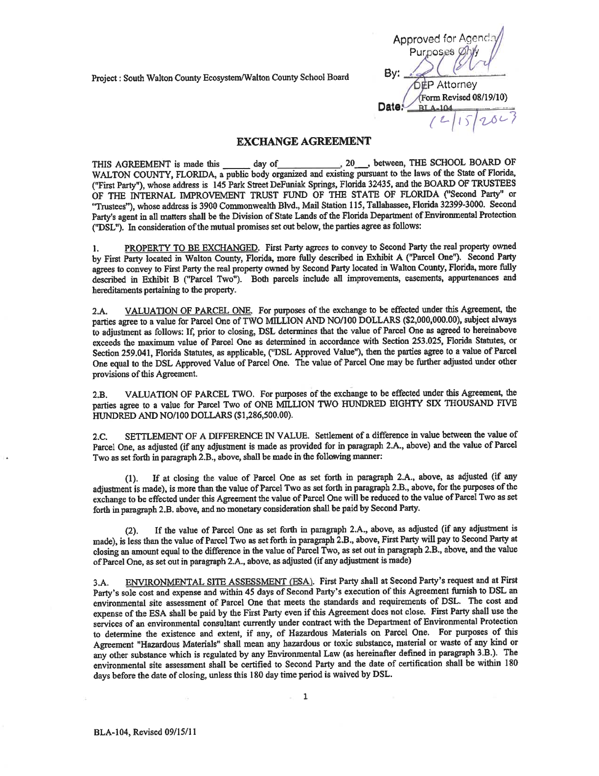
US Highway 98 W
Choctawhatchee
Bay
Gulf of
Mexico
US Highway 98 E
US Highway 331 S
Clyde B Wells Brg
Grayton Beach
State Park
Choctawhatchee
River Water
Management Area
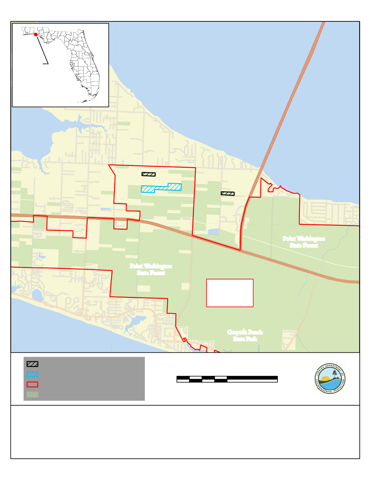
Point Washington
State Forest
Point Washington
State Forest
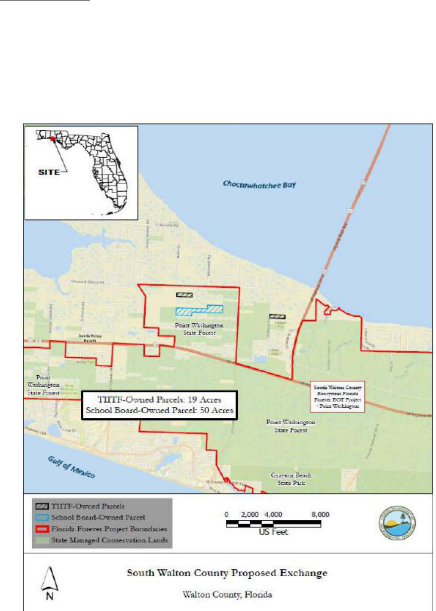
South Walton County
Ecosystem Florida
Forever BOT Project
- Point Washington
0 5,000 10,0002,500
US Feet
"
SITE
´
Date Saved: 11/13/2023 9:57 AM
File Location: \\floridadep\data\
Map Created By: K. Wyko, T. Barnes
W:\Counties_GIS\Walton\South_Walton_County_Proposed_Exchange_SchoolBoard
Point Washington State Forest
South Walton County Ecosystem
Walton County School Board Exchange
Walton County, Florida
State Managed Conservation Lands
Florida Forever Project Boundaries
School Board-Owned Parcels
TIITF-Owned Parcels
ATTACHMENT 4
PAGE 1
US Highway 98 W
Chat Holly Rd
Harstvedt Rd
Cox Rd
Nellie Dr
Old Blue Mountain Rd
US Hwy 331
JD Miller Rd
South Walton
High School
Choctawhatchee
Bay
Point Washington
State Forest
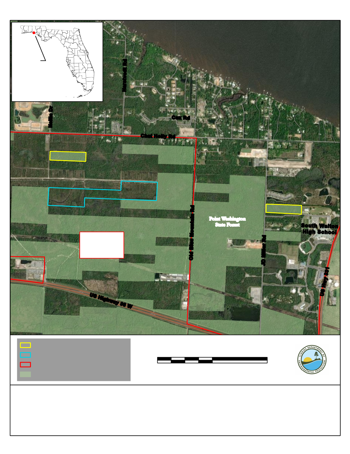
South Walton County
Ecosystem Florida
Forever BOT Project
- Point Washington
TIITF-Owned Parcels
School Board-Owned Parcels
Florida Forever Project Boundaries
State Managed Conservation Lands
0 2,000 4,0001,000
US F
eet
Point Washington State Forest
South Walton County Ecosystem
Walton County School Board Exchange
Walton County, Florida
"
SITE
´
Date Saved: 11/13/2023 9:57 AM
File Location: \\floridadep\data\
W:\Counties_GIS\Walton\South_Walton_County_Proposed_Exchange_SchoolBoard
Map Created By: K. Wyko, T. Barnes
ATTACHMENT 4
PAGE 2
ATTACHMENT 4
SUBSTITUTE PAGE 3
ATTACHMENT 4
SUBSTITUTE PAGE 4
ATTACHMENT 4
SUBSTITUTE PAGE 5
ATTACHMENT 4
SUBSTITUTE PAGE 6
ATTACHMENT 4
SUBSTITUTE PAGE 7
ATTACHMENT 4
SUBSTITUTE PAGE 8
ATTACHMENT 4
SUBSTITUTE PAGE 9
ATTACHMENT 4
SUBSTITUTE PAGE 10
ATTACHMENT 4
SUBSTITUTE PAGE 11
ATTACHMENT 4
SUBSTITUTE PAGE 12
ATTACHMENT 4
PAGE 13
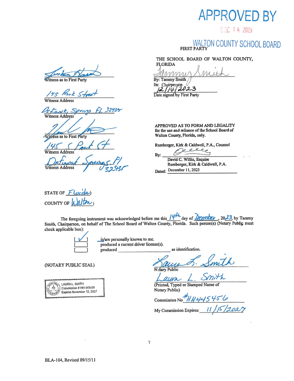
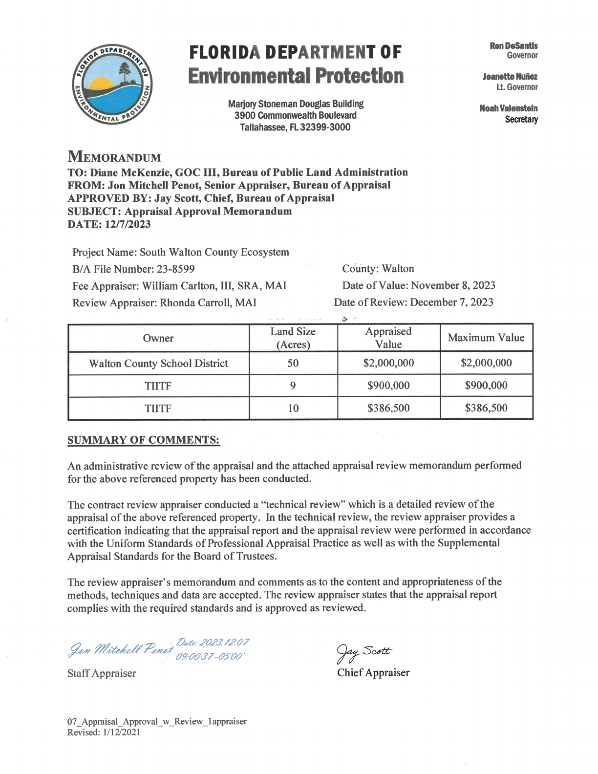
DATE: December 7, 2023
TO: Jon Mitchell Penot
Senior Appraiser
Bureau of Appraisal
FROM: Rhonda A. Carroll, MAI, AI-GRS
Fee Review Appraiser
Carroll Appraisal Company, Inc.
SUBJECT: DSL - School Board Exchange
South Walton County Ecosystem
B/A File #23-8599
Walton County, Florida
As requested, I have made a field review and technical review of the appraisal report for the parcels
referenced above. The appraisal was prepared by William (Bill) Carlton, MAI, SRA. The
report is dated December 6, 2023, and reflects a date of value of November 8, 2023.
GENERAL INFORMATION AND SCOPE OF REVIEW
The fee simple interest was appraised, subject to existing easements of record. The purpose of
the appraisal was to provide an opinion of the current market value of three parcels. Two parcels
are owned by the Board of Trustees of the Internal Improvement Trust Fund of the State of Florida
(TIITF) and the third is owned by Walton County School Board. The scope of this review
included inspecting the subject property. The appraisal report was reviewed to determine its
completeness, accuracy, adequacy, relevance, and reasonableness. Where necessary, revisions
were requested for clarification/corrections in the appraisal, and this review report reflects my
opinions after corrections have been received.
I possess geographic competence as I have been appraising real estate in this area for over 35 years.
By way of signing this review memorandum, I am concurring with the analysis and conclusions
in the appraisal. The appraisal was reviewed to determine its compliance with Supplemental
Appraisal Standards for Board of Trustees, revised March 2016, and the Uniform Standards of
Professional Appraisal Practice (2021-2022), extended to December 31, 2023.
After revisions, the appraisal complies with minimum appraisal standards as stated in both
publications. By way of signing this review memorandum, the appraisal is complete, and I have
formed the opinion that the appraisal is well supported.
ATTACHMENT 4
PAGE 14
MEMORANDUM
Jon Mitchell Penot
December 7, 2023
Page Two (2)
The following table summarizes the value conclusions reached by the appraiser:
Tract
Size
$/Acre
Total Value
50-acre School Board Tract
50 acres
$40,000
$2,000,000
9-acre TIITF Tract
9 acres
$100,000
$900,000
10-acre TIITF Tract
10 acres
$38,650
$386,500
*values subject to “private sector” zoning, rather than “Conservation.”
CLIENT
The client of the appraisal and of the review is the Bureau of Appraisal of the Department of
Environmental Protection.
INTENDED USE/INTENDED USERS
The intended use of the appraisal is to assist the client and the intended users in making decisions
regarding the potential exchange of the subject parcels. The intended users of the appraisal are the
Bureau of Appraisal of the Florida Department of Environmental Protection (DEP) and the Board
of Trustees of the Internal Improvement Trust Fund of the State of Florida (TIITF). There are no
other authorized users of the report.
The intended use of this appraisal review is to assist the reader in forming an opinion regarding
the reliability of the appraisal under review and to address compliance with the applicable appraisal
standards.
PURPOSE OF THE REVIEW
The purpose of the review is to form an opinion as to the completeness and appropriateness of the
methodology and techniques utilized to form an opinion as to the value of the subject properties
and to assure that the appraisal conforms to the Uniform Standards of Professional Appraisal
Practice (USPAP) and Supplemental Appraisal Standards for the Board of Trustees (SASBOT).
EXTRAORDINARY ASSUMPTIONS
An assumption, directly related to a specific assignment, as of the effective date of the assignment
results, which, if found to be false, could alter the appraiser’s opinions or conclusions. Comment:
Extraordinary assumptions presume as fact otherwise uncertain information about physical, legal,
or economic characteristics of the subject property; or about conditions external to the property,
such as market conditions or trends; or about the integrity of data used in an analysis. There are
no extraordinary assumptions in the appraisal or in the review of the appraisal.
ATTACHMENT 4
PAGE 15

MEMORANDUM
Jon Mitchell Penot
December 7, 2023
Page Three (3)
HYPOTHETICAL CONDITIONS
A condition directly related to a specific assignment, which is contrary to what is known by the
appraiser to exist on the effective date of the assignment results but is used for the purpose of
analysis. Comment: Hypothetical conditions are contrary to known facts about physical, legal, or
economic characteristics of the subject property; or about conditions external to the property, such
as market conditions or trends; or about the integrity of data used in an analysis.
For valuation purposes, the appraiser has made the appraisal subject to the hypothetical condition
that each of the three parcels would carry the zoning of adjacent/nearby, similar private sector
tracts. This is a reasonable conclusion, given the present Conservation zoning.
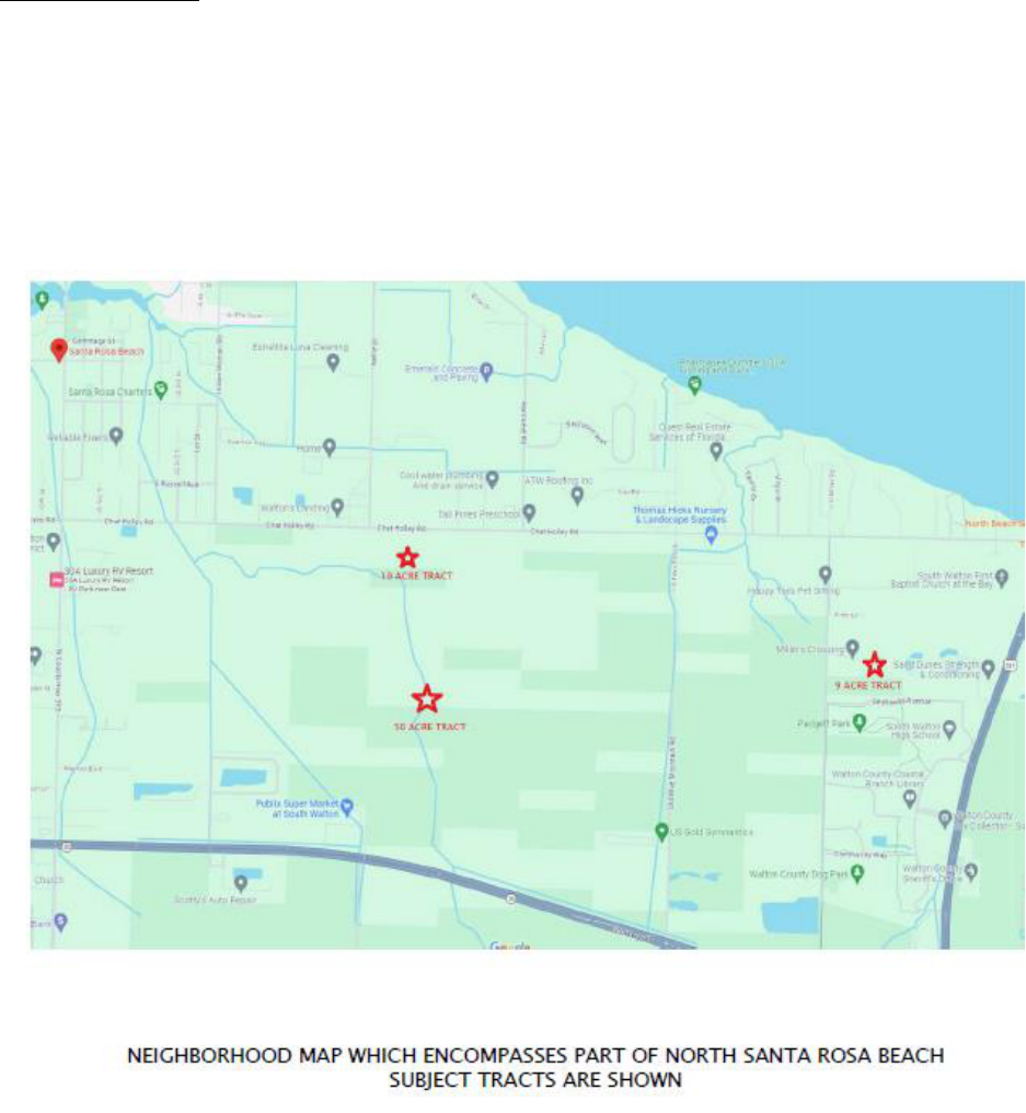
NEIGHBORHOOD DESCRIPTION
The neighborhood comprises a large area in South Walton County. Generally speaking, macro-
neighborhood boundaries can be loosely delineated by the Choctawhatchee Bay on the north, U.S.
Highway 331 on the east, the Gulf of Mexico on the south, and Okaloosa County (Sandestin) on
the west.
The micro-neighborhood comprises North Santa Rosa Beach. Santa Rosa Beach extends from the
Choctawhatchee Bay on the north to the Gulf of Mexico on the south. North Santa Rosa Beach
does not extend southerly to the Gulf of Mexico and is located between U.S. Highway 98 and
Choctawhatchee Bay.
Micro-neighborhood boundaries can be delineated by the Choctawhatchee Bay on the north, U.S.
Highway 331 on the east, U.S. Highway 98 and the south, and County Road 393/Churchill Bayou
Road at the intersection of North County Road 393 on the west.
Transportation through the neighborhood is adequate. Four lane U.S. Highway 331 runs along the
east boundary of the neighborhood and runs north from U.S. Highway 98 to Defuniak Springs.
Four lane U.S. Highway 98 runs east-west at the south boundary of the neighborhood from Panama
City on the east to Pensacola on the west. Highway 30-A loops U. S. Highway 98 beginning just
west of the Bay County line and running along the Beach in a westerly direction back to U.S.
Highway 98 near the intersection of East Hewett Road.
The subject properties and much of North Santa Rosa Beach are located in an old platted
subdivision known as Santa Road Plantation. The plat was recorded in 1904. Santa Rosa Plantation
generally consists of uniform lots, blocks and roadway easements laid out in a 90-degree compass
rose alignment. The individual lots comprise approximately 9.75 to 10 acres in size. North to south
road easements or right of ways are located on the same geodetic axes.
ATTACHMENT 4
PAGE 16

MEMORANDUM
Jon Mitchell Penot
December 7, 2023
Page Four (4)
That part of Nellie Drive south of Chat Holly Road, where the subject 50-acre tract and the 10-
acre lot are located, will be paved from Chat Holly Road to U. S. Highway 98 in the near future.
Funding is already in place for the project ($3,200,000) and the project is currently in the design
phase with 60% of the design work having been completed. Concurrent with road construction,
Regional Utilities will provide water and sewer along Nellie Drive and Choctawhatchee Electric
Cooperative will provide electricity. Construction of the project should start in 2024 and be
completed in early 2025.
There is not much available land to build upon in South Walton County. Consequently, the price
for development land is very expensive. The average household cannot afford housing south of
U.S. Highway 98 in the County Road 30-A area because of the influence of the Gulf of Mexico.
As a result, most new residential construction that is affordable (even that is very expensive) is
being built in North Santa Rosa Beach between the Choctawhatchee Bay and U.S. Highway 98.
A part of Point Washington State Forest is located within the North Santa Rosa Beach area further
restricting the amount of developable land available. Almost 80% of the undeveloped land area
between U. S. Highway 98 that is undeveloped and located in Point Washington State Forest.
Most of the new construction in the area is located on Chat Holly Road, J. D. Miller Road, North
Nellie Drive, Indian Woman Drive, Harstvedt Road, and North Eden Park Drive.
New residential construction in the neighborhood consists of Walton Landing (townhouses and
detached single family residences), Hawks Landing (townhouses), Southern Pines (detached
single-family residences), Mosaic Oaks (detached single-family residences), 30 North (detached
single family), Harstvedt Plantation (single family residences), Santa Rosa Beach Townhomes
(townhouses), The Southern At Santa Road Beach (garden apartments), and Miller’s Crossing
(townhouses).
The appraiser has provided a good description of the neighborhood in his appraisal, with a detailed
description of boundaries, linkages and near-by uses.
The maps on the following pages depict all three parcels:
ATTACHMENT 4
PAGE 17
MEMORANDUM
Jon Mitchell Penot
December 7, 2023
Page Five (5)
ATTACHMENT 4
PAGE 18
MEMORANDUM
Jon Mitchell Penot
December 7, 2023
Page Six (6)
ATTACHMENT 4
PAGE 19

MEMORANDUM
Jon Mitchell Penot
December 7, 2023
Page Seven (7)
50-ACRE SCHOOL BOARD PARCEL
BRIEF DESCRIPTION OF PROPERTY
The property comprises 50 acres of wooded land in North Santa Rosa Beach, located in Walton County
between the Choctawhatchee Bay on the north, U. S. Highway 98 on the south and U. S. Highway 331 on
the east, in a high growth area.
OWNER OF RECORD
School Board of Walton County
145 Park Avenue
Defuniak Springs, Florida 32435
PRIOR SALES PAST FIVE YEARS/CURRENT LISTING HISTORY
The subject property and other land was purchased for $3,300,000 in December of 2020. There is
no current listing of the parcel and other than this possible exchange, no known offers to purchase.
SITE DESCRIPTION
The property comprises 50 acres, subject to a survey. The tract generally lies north of U. S.
Highway 98, south of Choctawhatchee Bay, east of County Road 393, and west of U. S. Highway
331. Chat Holly Road from the northern extent of the area and is located a few hundred feet north
of the subject tract. Chat Holly Road consists of developed and undeveloped commercial and
residential properties. There is considerable building activity in the area.
Public forest lands (Point Washington State Forest) bind the west, south and east boundaries of the
property. A gated access point is located south of the Chat Holly Road and Nellie Road
intersection. Santa Rosa Plantation Subdivision generally consists of uniform lots, blocks and
roadway easements laid out in a 90-degree compass rose alignment. The individual lots typically
comprise approximately 9.75 to 10 acres in size. North to south road easements or right of ways
are located on the same geodetic axes. Nellie Drive breaks the continuity of a common border
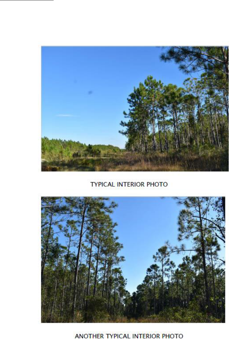
among the individual lots. The property has been actively managed as pine plantation silviculture
in various stages of timber production. Because the property lies within the floodplain, the pines
were planted on beds and there are various drainage ditches running through the property.
There are currently no utilities to the property. As part of the extension and paving of Nellie Drive,
The appraiser has confirmed with at Regional Utilities that they will provide sewer and water lines
along Nellie Drive concurrent with the paving of Nellie Drive Extension. Choctawhatchee Electric
Cooperative will provide electrical lines along Nellie Drive Extension.
ATTACHMENT 4
PAGE 20
MEMORANDUM
Jon Mitchell Penot
December 7, 2023
Page Eight (8)
The property currently carries the zoning classification of Conservation. The zoning designation
is usually given to state or county owned lands and private lands subject to a conservation
easement. Within the neighborhood, most all lands owned by the State of Florida or Walton County
are zoned Conservation. Residential and commercial development are not allowed in conservation
zoning. Primary uses are state forests, state parks and recreational areas, county parks, timber
lands, and recreational lands. The appraisal reflects the hypothetical condition that if the property
were not owned by a public entity, the zoning would be consistent with private-sector tracts in the
immediate area, similar to the subject tract.
The appraiser has provided a good description of the site and the improvements in his appraisal.
EASEMENTS, RESERVATIONS AND RESTRICTIONS
There are no known noted easements, reservations or restrictions that would adversely affect the
use of the property.
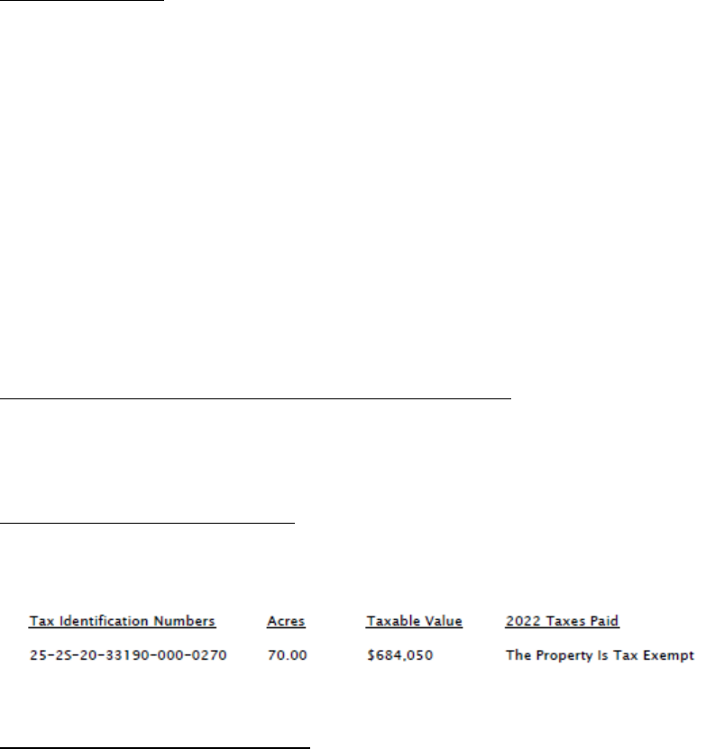
ASSESSMENT INFORMATION
The following table reflects the assessment information for the subject parcel:
It is noted that the property is part of a 70-acre parcel.
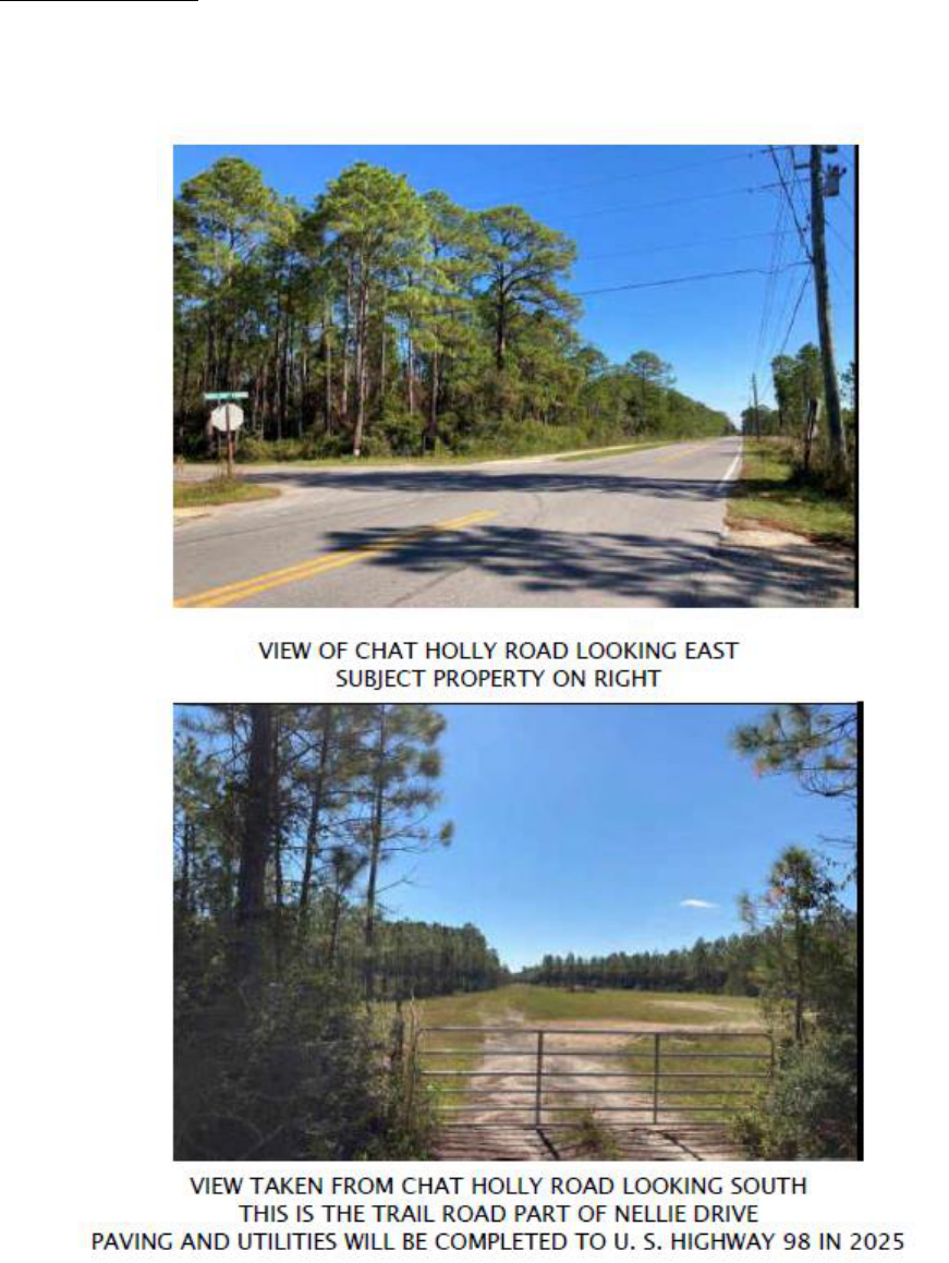
MAPS, PHOTOS AND EXHIBITS
Photos of the subject tract follow on the next two pages.
ATTACHMENT 4
PAGE 21
MEMORANDUM
Jon Mitchell Penot
December 7, 2023
Page Nine (9)
ATTACHMENT 4
PAGE 22
MEMORANDUM
Jon Mitchell Penot
December 7, 2023
Page Ten (10)
ATTACHMENT 4
PAGE 23

MEMORANDUM
Jon Mitchell Penot
December 7, 2023
Page Eleven (11)
HIGHEST AND BEST USE
The concept of highest and best use is based upon the premise that a property should be valued
based on the use which will produce the highest market value and the greatest financial return.
his use must be legally permissible, physically possible, financially feasible and maximally
productive.
Mr. Carlton concluded that the highest and best use of the tract is to improve the property with
single-family residences or townhouses, clustering where necessary.
Given the location of the tract and the considerable amount of development in the area, this is a
reasonable conclusion.
VALUATION
For tracts with a highest and best use of residential, the most applicable approach is the Direct
Sales Comparison Approach. This approach has as its premise a direct comparison of the subject
property with recent sales of similar tracts in the area.
Mr. Carlton analyzed three private-sector sales and two government sales. Despite the fact that
two of the sales were purchased by governmental bodies, these sales were based on appraisals of
the tracts and the final consideration paid was deemed to be the same as what would have been
paid by the private sector. Regardless, per State requirements, the private sector sales were
analyzed separately from the government sales. The five sales ranged in sales price from
$2,050,000 to $9,900,000. The adjusted price per acre ranged from approximately $38,000 to
approximately $150,000 per acre. Placing most weight on the most comparable sales, Mr. Carlton
correlated to $40,000 per acre. When this figure was applied to the subject’s 50 acres, a value of
$2,000,000 resulted.
Mr. Carlton’s conclusion is reasonable and is well supported. His sales share the same highest and
best use as the subject.
ATTACHMENT 4
PAGE 24

MEMORANDUM
Jon Mitchell Penot
December 7, 2023
Page Twelve (12)
9-ACRE TIITF PARCEL
BRIEF DESCRIPTION OF PROPERTY
The property comprises 9 acres of wooded land in North Santa Rosa Beach, located in Walton County
between the Choctawhatchee Bay on the north, U. S. Highway 98 on the south and U. S. Highway 331 on
the east, in a high growth area.
OWNER OF RECORD
TIITF/AG-FORESTRY AND GFWFC
Topsail Hill/Point Washington
3900 Commonwealth Blvd
Tallahassee, Florida 32399
PRIOR SALES PAST FIVE YEARS/CURRENT LISTING HISTORY
The subject property and other land was purchased by the State in 1992. There is no current listing
of the parcel,and other than this possible exchange, no known offers to purchase.
SITE DESCRIPTION
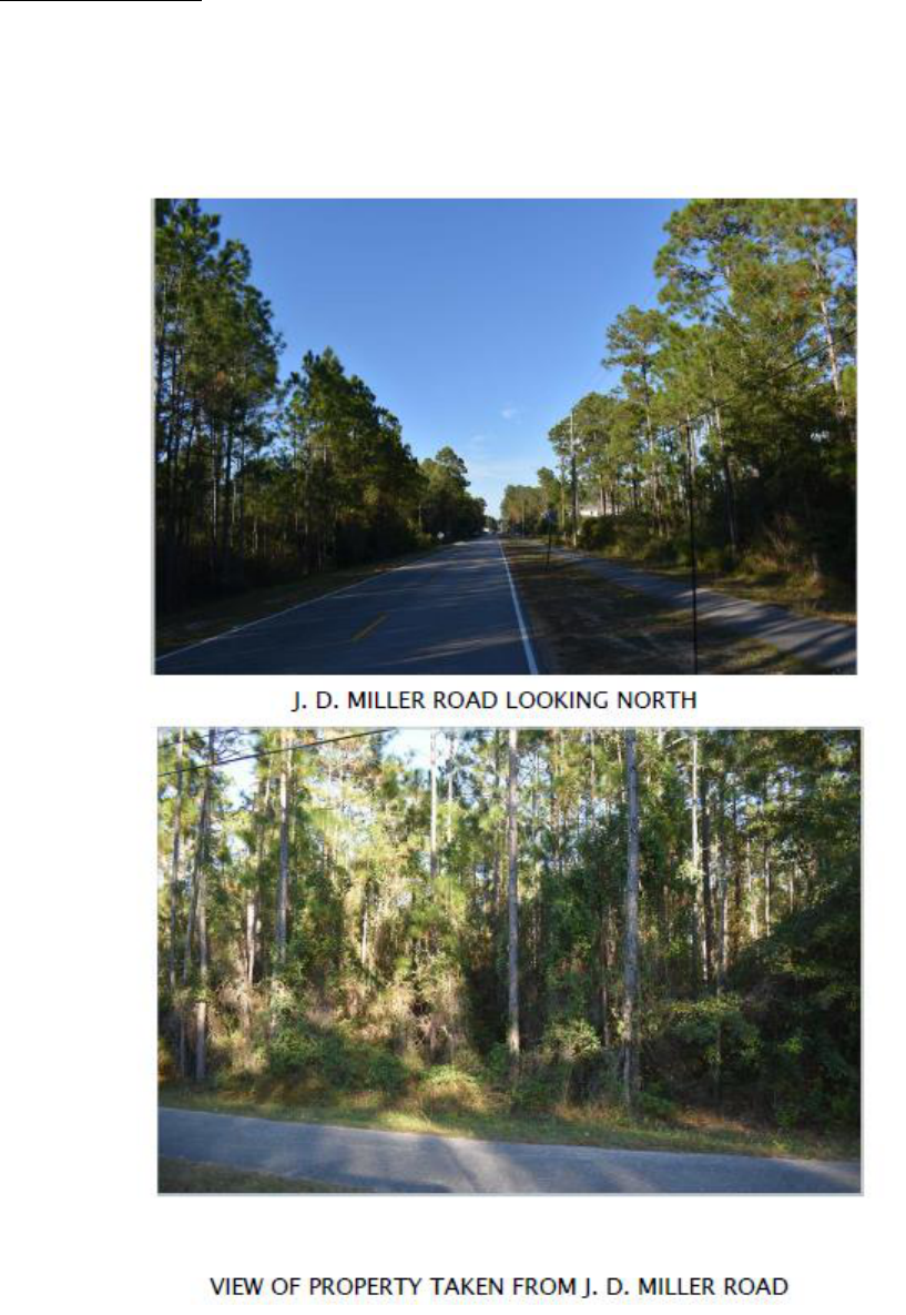
The property is located approximately 2,280 feet south of Chat Holly Road and 125 feet north of
Seahawks Avenue, which provides rear access to South Walton High School. in the North Santa
Rosa Beach Community.
Access is provided by J.D. Miller Road, a county paved road. Approximately 33% of the property
is located within wetland areas. The tract is rectangular shaped and, from scaling Walton County
Property Appraiser Maps, has approximate dimensions of 300 feet x 1,300 feet and contains
approximately nine acres.
The property carries the zoning classification of Conservation. The zoning designation is usually
given to state or county owned lands and private lands subject to a conservation easement. Within
the neighborhood, most all lands owned by the State of Florida or Walton County are zoned
Conservation. Residential and commercial development are not allowed in conservation zoning.
Primary uses are state forests, state parks and recreational areas, county parks, timber lands, and
recreational lands.
The property has been appraised based upon its highest and best use as supported by surrounding
private sector zoning, which is Village Mixed Use and Town Center One, allowing up to 12
residential units per acre.
The appraiser has provided a good description of the site in his appraisal.
ATTACHMENT 4
PAGE 25
MEMORANDUM
Jon Mitchell Penot
December 7, 2023
Page Thirteen (13)
EASEMENTS, RESERVATIONS AND RESTRICTIONS
There are no known noted easements, reservations or restrictions that would adversely affect the
use of the property.
ASSESSMENT INFORMATION
The following table reflects the assessment information for the subject parcel:
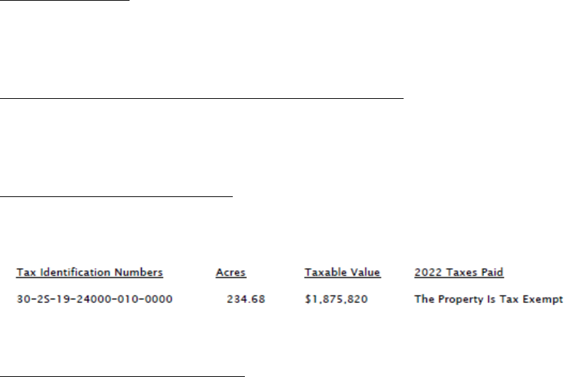
It is noted that the property is part of a 234.68-acre parcel.
MAPS, PHOTOS AND EXHIBITS
Photos of the tract are on the following page.
ATTACHMENT 4
PAGE 26
MEMORANDUM
Jon Mitchell Penot
December 7, 2023
Page Fourteen (14)
ATTACHMENT 4
PAGE 27

MEMORANDUM
Jon Mitchell Penot
December 7, 2023
Page Fifteen (15)
HIGHEST AND BEST USE
The concept of highest and best use is based upon the premise that a property should be valued
based on the use which will produce the highest market value and the greatest financial return.
his use must be legally permissible, physically possible, financially feasible and maximally
productive.
Mr. Carlton concluded that the highest and best use of the tract is to develop it in accordance with
what is consistent with the private-sector tracts in the area. This would reflect residential
development up to 12 units per acre.
Given the location of the tract and the considerable amount of development in the area, this is a
reasonable conclusion.
VALUATION
For tracts with a highest and best use of residential, the most applicable approach is the Direct
Sales Comparison Approach. This approach has as its premise a direct comparison of the subject
property with recent sales of similar tracts in the area.
Mr. Carlton analyzed four private-sector sales. The sales ranged in sales price from $850,000 to
$3,800,000. The adjusted price per acre ranged from approximately $62,000 to approximately
$150,000 per acre. Placing most weight on the most comparable sales, Mr. Carlton correlated to
$100,000 per acre. When this figure was applied to the subject’s 9 acres, a value of $900,000
resulted.
Mr. Carlton’s conclusion is reasonable and is well supported. His sales share the same highest and
best use as the subject.
ATTACHMENT 4
PAGE 28

MEMORANDUM
Jon Mitchell Penot
December 7, 2023
Page Sixteen (16)
10-ACRE TIITF PARCEL
BRIEF DESCRIPTION OF PROPERTY
The property comprises 9 acres of wooded land in North Santa Rosa Beach, located in Walton County
between the Choctawhatchee Bay on the north, U. S. Highway 98 on the south and U. S. Highway 331 on
the east, in a high growth area.
OWNER OF RECORD
TIITF/AG-FORESTRY AND GFWFC
Topsail Hill/Point Washington
3900 Commonwealth Blvd
Tallahassee, Florida 32399
PRIOR SALES PAST FIVE YEARS/CURRENT LISTING HISTORY
The subject property and other land was purchased by the State in 1992. There is no current listing
of the parcel and other than this possible exchange, no known offers to purchase.
SITE DESCRIPTION
The property comprises 10 acres, subject to a survey. The tract generally lies north of U. S.
Highway 98, south of Choctawhatchee Bay, east of County Road 393, and west of U. S. Highway
331. Chat Holly Road from the northern extent of the area and is located a few hundred feet north
of the subject lot. Chat Holly Road consists of developed and undeveloped commercial and
residential properties. There is a lot of building activity in the area.
Public forest lands (Point Washington State Forest) bind the west, south and east boundaries of the
property. A gated access point is located south of the Chat Holly Road and Nellie Road
intersection. Santa Rosa Plantation Subdivision generally consists of uniform lots, blocks and
roadway easements laid out in a 90-degree compass rose alignment. The individual lots typically
comprise approximately 9.75 to 10 acres in size. North to south road easements or right of ways
are located on the same geodetic axes. Nellie Drive breaks the continuity of a common border
among the individual lots. The property has been actively managed as pine plantation silviculture
in various stages of timber production. Because the property lies within the floodplain, the pines
were planted on beds and there are various drainage ditches running through the property.
ATTACHMENT 4
PAGE 29

MEMORANDUM
Jon Mitchell Penot
December 7, 2023
Page Seventeen (17)
There are currently no utilities to the property. As part of the extension and paving of Nellie Drive,
The appraiser has confirmed with at Regional Utilities is that they will provide sewer and water
lines along Nellie Drive concurrent with the paving of Nellie Drive Extension. Choctawhatchee
Electric Cooperative will provide electrical lines along Nellie Drive Extension.
Access is by a public easement or dedicated right of way from Chat Holly Road that is currently a
trail road on Nellie Drive (not named at this time). There is a locked gate at the intersection of
Chat Holley Road. The subject property fronts on Nellie Drive, again, a trail road at this time.
Nellie Drive will be paved from Chat Holley Road south to U. S. Highway 98. Funding is already
in place for the project ($3,200,000) and the project is currently in the design phase with 60% of
the design work having been completed. Road construction will start in 2024 and the project is
expected to be completed in early 2025.
The tract is irregular in shape and has approximate dimensions of 330 feet (on what will become
paved South Nellie Drive) x 1,320 feet, containing approximately 10 acres.
The property carries the zoning classification of Conservation. The zoning designation is usually
given to state or county owned lands and private lands subject to a conservation easement. Within
the neighborhood, most all lands owned by the State of Florida or Walton County are zoned
Conservation. Residential and commercial development are not allowed in conservation zoning.
Primary uses are state forests, state parks and recreational areas, county parks, timber lands, and
recreational lands. The property has been appraised based upon its highest and best use as
supported by surrounding private sector zoning, which is Conservation Residential, allowing two
units per acre.
The appraiser has provided a good description of the site in his appraisal.
EASEMENTS, RESERVATIONS AND RESTRICTIONS
There are no known noted easements, reservations or restrictions that would adversely affect the
use of the property.
ASSESSMENT INFORMATION
The following table reflects the assessment information for the subject parcel:
It is noted that the property is part of a 302-acre parcel.
MAPS, PHOTOS AND EXHIBITS
Photos of the tract are on the following page.
ATTACHMENT 4
PAGE 30

MEMORANDUM
Jon Mitchell Penot
December 7, 2023
Page Eighteen (18)
ATTACHMENT 4
PAGE 31

MEMORANDUM
Jon Mitchell Penot
December 7, 2023
Page Nineteen (19)
HIGHEST AND BEST USE
The concept of highest and best use is based upon the premise that a property should be valued
based on the use which will produce the highest market value and the greatest financial return.
his use must be legally permissible, physically possible, financially feasible and maximally
productive.
Mr. Carlton concluded that the highest and best use of the tract as vacant is to develop the tract in
accordance with what is consistent with the private-sector tracts in the area. This would be
Conservation Residential, allowing development of up to two units per acre.
Given the location of the tract and the considerable amount of development in the area, this is a
reasonable conclusion.
VALUATION
For tracts with a highest and best use of residential, the most applicable approach is the Direct
Sales Comparison Approach. This approach has as its premise a direct comparison of the subject
property with recent sales of similar tracts in the area.
Mr. Carlton analyzed three private-sector sales and two government sales. Despite the fact that
two of the sales were purchased by governmental bodies, these sales were based on appraisals of
the tracts and the final consideration paid was deemed to be the same as what would have been
paid by the private sector. Regardless, per State requirements, the private sector sales were
analyzed separately from the government sales. The five sales ranged in sales price from
$300,000 to $2,500,000. The adjusted price per acre ranged from approximately $34,000 to
approximately $62,000 per acre. Placing most weight on the most comparable sales, Mr. Carlton
correlated to $38,650 per acre. When this figure was applied to the subject’s 10 acres, a value of
$386,500 resulted.
Mr. Carlton’s conclusion is reasonable and is well supported. His sales share the same highest and
best use as the subject.
REVIEWER’S COMMENTS
Mr. Carlton considered ten total sales in the valuation of the three parcels. Eight of the sales were
private sector sales, while the remaining two were governmental sales. All ten sales are
considered to be reliable indicators of the values of the tracts. The sales have similar uses to what
the ultimate uses of the subject tracts would be if owned by the private sector.
ATTACHMENT 4
PAGE 32

MEMORANDUM
Jon Mitchell Penot
December 7, 2023
Page Twenty (20)
The scope of the review involves developing an opinion to address the five specific qualities in the
work under review. These include completeness, accuracy, adequacy, relevance and
reasonableness.
• Completeness: The appraisal report satisfies the requirements of the Supplemental
Appraisal Standards for the Board of Trustees and the Uniform Standards of Professional
Appraisal Practice. The scope of my review did not require that I conclude any opinions
of value.
• Accuracy: Overall, the report meets the general requirements described in the appraisal
instructions specific to the assignment and accurately reflects the assignment conditions.
The math and analysis contained within the report under review is accurate. The report
accurately discuss the approaches to value used, and those not used. The valuation
methodologies used are appropriate and correctly applied.
• Adequacy: The work presented in the appraisal report meets the minimum requirements
for its intended use. Following the stated scope of work in the appraisal, and in
compliance with the Supplemental Appraisal Standards for the Board of Trustees (March
2016), the documentation, verification, information, data, support and analysis in the report
is adequate and meets minimum requirements.
• Relevance: Overall, the appraisal report contains significant data and reasonable analysis
that is appropriate and relevant to the conclusions and opinions. The Sales Comparison
Approach was relevant and applicable in the appraisal report, as it mirrors the thinking of
buyers and sellers in the marketplace. Qualitative analysis of the subject and sales was
used in the appraisal, in which the appraiser relied upon logical reasoning to differentiate
the magnitude of a positive or negative adjustment in areas which required adjustment.
The appraiser did not consider the Cost nor Income approach to value, as they were not
considered relevant to the valuation of the property.
• Reasonableness: The data, analyses, conclusions, and opinions of value in the report are
considered reasonable and adequately supported overall.
Based on these conclusions, I find the appraisal report for the subject property to be reasonably
supported, appropriately analyzed, and adequately performed in accordance with generally
accepted appraisal practices. Further, I find the opinion of value to be credible and adequately
supported given the scope of work, and the intended use of the appraisal.
Therefore, it is my opinion that the appraisal meets the requirements of the Supplemental Appraisal
Standards for Board of Trustees, revised March 2016 and the Uniform Standards of Professional
Appraisal Practice (2021-2022), extended to December 31, 2023.
THE REVIEWER APPROVES THE APPRAISAL REPORT
ATTACHMENT 4
PAGE 33

CERTIFICATION
I certify that, to the best of my knowledge and belief:
• The statements of fact contained in this report are true and correct.
• The reported analyses, opinions, and conclusions are limited only by the reported assumptions and limiting conditions and
are my personal, impartial, and unbiased professional analyses, opinions, and conclusions.
• I have no present or prospective interest in the property that is the subject of the work under review and no personal interest
with respect to the parties involved.
• I have no bias with respect to the property that is the subject of the work under review or to the parties involved with this
assignment.
• My engagement in this assignment was not contingent upon developing or reporting predetermined results.
• My compensation is not contingent on an action or event resulting from the analyses, opinions, or conclusions in this review
or from its use.
• My compensation for completing this assignment is not contingent upon the development or reporting of predetermined
assignment results or assignment results that favors the cause of the client, the attainment of a stipulated result, or the
occurrence of a subsequent event directly related to the intended use of this appraisal review.
• I have performed no services, as an appraiser or in any other capacity, regarding the subject of the work under review within
the three-year period immediately preceding the agreement to perform this assignment.
• My analyses, opinions, and conclusions were developed, and this report has been prepared, in conformity with the Uniform
Standards of Professional Appraisal Practice.
• I have the knowledge of the assignment and the competency to determine the market value of the property assigned. I hold
the MAI and AI-GRS review designations of the Appraisal Institute. I am certified in the State of Florida.
• I have made a personal inspection of the subject of the work under review.
• No one provided significant appraisal or appraisal review assistance to the person signing this certification.
• The reported analyses, opinions, and conclusions were developed, and this report has been prepared in conformity with the
Code of Professional Ethics and Standards of Professional Appraisal Practice of the Appraisal Institute.
• The use of this report is subject to the requirements of the Appraisal Institute relating to review by its duly authorized
representatives.
• As of the date of this report, I have completed the continuing education program for Designated Members of the Appraisal
Institute. I am certified under this program through December 2023. The review is subject to the requirements of the Appraisal
Institute relating to review by its duly authorized representatives.
• The appraisal reviewed is in substantial compliance with USPAP, and SASBOT, as well as Rule 18-1.006, Florida
Administrative Code (FAC).
December 7, 2023
Rhonda A. Carroll, MAI, AI-GRS, AI-RRS Date
State Certified General Real Estate Appraiser RZ 459
ATTACHMENT 4
PAGE 34
ATTACHMENT 4
PAGE 35
